
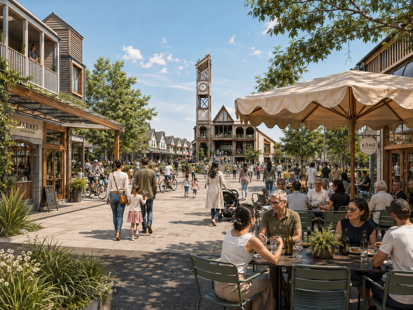
Masterplanning · Conceptual urban study · Paeroa
Low rise, medium-density - Paeroa
A staged framework for walkable urbanism, linking rapid transit, compact low-rise neighbourhoods, shared green space, mixed uses and public squares - a hypothetical design adapted from a thesis study originally by Stephen Pattinson, Gabrielle McInnes and Mark de Lisle.
The proposition
From dispersed development to compact walkable urbanism
The objective is not density for its own sake. It is to create a settlement pattern compact enough for everyday life to work on foot — with homes, public transport, shops, work, community facilities, recreation and shared open space connected as one coherent neighbourhood structure.
The project develops ideas first explored in Stephen's architectural research into a staged, low-energy, medium-density settlement. A central premise was that human-scaled two- and three-storey buildings can be grouped closely together, releasing larger shared spaces while reducing the distances, infrastructure and movement associated with dispersed development.
For Paeroa, that becomes an urban design strategy rather than a single fixed masterplan: strengthen the existing town, connect it to rapid transit, build compact neighbourhoods around common ground, and allow the structure to grow incrementally over time.
Walkable urbanism
Compactness, mixed uses, connected pedestrian routes, public transport and shared spaces work together. The alternative is not simply lower density; it is car-dependent development in which everyday destinations are too dispersed for walking to become the normal way of moving around.
Regional structure
Rapid transit links a network of walkable settlements
A compact neighbourhood works best as part of a wider network rather than as an isolated enclave.
At the regional scale, the model connects several transit-oriented developments (TODs) by a continuous rapid-transit line. The line passes through each settlement and continues onward to other destinations rather than terminating at one development.
Within each TOD, the station and public square become an organising focus. Mixed-use buildings, cafés, shops and the highest residential intensity sit closest to this centre; medium- and lower-density housing steps outward into neighbourhood greens, community facilities and productive landscapes such as orchards, horticulture, pasture and forestry.
The resulting pattern is deliberately more organic and concentric than a rectangular suburban grid: clustered neighbourhoods expand outward from the transit node and town centre while remaining tied together by pedestrian routes, green space and local destinations.
Paeroa
An incremental conversion, not wholesale replacement
The town can become more walkable in stages, building on what already exists.
The Paeroa study begins with the existing dispersed town structure and shows a possible sequence of change. The first move is to strengthen a recognisable town square and establish the first compact neighbourhoods around it. A strong pedestrian boulevard or public street connects the centre to the railway station, which sits off-centre rather than needing to occupy the geometric middle of the town.
Further neighbourhoods can then be added as demand and opportunity arise. Over time, these pieces form a connected urban structure of streets, greens, squares and neighbourhood clusters. The point of staging is that each step should work in its own right while also contributing to the longer-term pattern.
This allows Paeroa to grow without losing its existing town, landscape setting or identity. The strategy is evolutionary: add enough compactness and connectivity to make walking viable, while preserving substantial green and productive land around the urban form.
Design framework
A simple grammar for compact walkable neighbourhoods
The masterplan is guided by a small number of spatial rules rather than a rigid final layout.
The design grammar brings together six ideas: middle-scale one- to three-storey built form; housing clustered around shared space; a clear private-to-communal-to-public gradient; neighbourhoods sized around an easy walk; streets and squares shaped by building edges; and incremental growth that can extend the pattern without losing its walkability.
These principles reinforce one another. Low-rise compactness provides human scale; clustering releases meaningful communal open space; mixed-use edges give public streets activity; and staged growth allows a town to adapt rather than depending on one large redevelopment event.
Neighbourhood scale
Cluster homes around common ground
The neighbourhood is the basic building block of the wider settlement.
A neighbourhood of about 70 dwellings illustrates how medium-density housing can be concentrated around a generous communal landscape rather than dispersed across individually fenced lots. The shared green becomes a real piece of neighbourhood infrastructure: a place for walking, sitting, play, informal gathering, planting and everyday contact between neighbours.
The buildings remain predominantly low-rise and domestic in scale, but the tighter grouping allows the centre of the cluster to feel spacious. Front doors, balconies, paths and shared outdoor rooms overlook the common ground, giving the neighbourhood both identity and a recognisable social heart.
This is the opposite of treating open space as whatever land happens to be left after roads, parking and individual lots are laid out. Here, the space between buildings is designed first as part of the settlement structure.
Spatial hierarchy
Move gradually from private life to public life
Good urban housing needs more than a front door opening directly onto either a private yard or a public street.
The spatial spectrum introduces layers between the individual dwelling and the wider city. Private rooms provide retreat; family rooms connect to semi-private thresholds; communal spaces belong to the housing cluster; public streets and squares belong to everyone; and active ground-floor shops and services animate the public edge.
These transitions matter because they allow sociability without sacrificing privacy. A resident can sit at the edge of a communal space, pass a neighbour on a shared path, stop briefly at a café, or withdraw into the home. The settlement supports different degrees of participation rather than requiring either isolation or constant interaction.
The hierarchy also clarifies where different activities belong, making streets easier to read and giving communal spaces a stronger sense of ownership and care.
Connecting neighbourhoods
Public squares join the clusters together
Neighbourhood greens provide intimacy; public squares provide shared civic life.
Individual housing clusters are linked by pedestrian public streets that converge at public squares. The square is not an isolated plaza placed beside the neighbourhoods: it sits on the natural routes between them, so everyday movement continually feeds activity into the space.
At these points the urban form becomes more mixed. Cafés, shops and community uses occupy the ground floor with housing above, while communal courtyards remain protected within the housing clusters. The result is a legible hierarchy: home, shared courtyard, pedestrian street, public square, town.
Because the public square is formed by the buildings around it, it gains enclosure, address and identity. It becomes a place to meet, shop, eat, sit, play, pass through or hold local events — a multivalent shared space rather than a single-purpose traffic area.
The civic heart
A public square for everyday life
The quality of the public realm is what turns compactness into urbanity.
The public square is the social and civic heart of the walkable neighbourhood. Buildings define its edges rather than sitting back behind parking; shops, cafés and upper-floor uses overlook it; trees and planting provide comfort; and walking and cycling remain visible parts of everyday life.
Its value comes from supporting many things at once. The same space can accommodate movement, outdoor dining, conversation, children, markets, informal performances, civic events and simple people-watching. Activity at ground level gives the square life, while upper floors add residents and workplaces that keep the centre occupied beyond a single time of day.
For Paeroa, this kind of square can provide a recognisable centre within a larger network of neighbourhoods — a place that belongs to the town as a whole while remaining closely connected to daily residential life.
The wider idea
A town that can grow without becoming more dispersed
The project is a framework for change over time, not a blueprint requiring everything to be built at once.
Low rise, medium-density - Paeroa brings together several scales of design: regional rapid transit; the town centre and civic square; walking-distance neighbourhoods; housing clusters around shared green space; and the thresholds between private, communal and public life.
Its central proposition is that growth can be accommodated through compactness rather than sprawl. New housing can increase the number of people living within walking distance of the centre and transport, while productive land, larger green areas and the landscape around Paeroa remain distinct from the urban structure.
The result is intended to be neither conventional suburbia nor large-city high-rise development. It is a middle-scale form of urbanism: low-rise, connected, mixed, green, walkable and capable of growing in stages.
Masterplanning
Planning connected places
Explore further PPL work in neighbourhood structure, communal space and the design of places between buildings.
Start a conversation
Planning a project?
Contact Stephen to discuss your site, your brief and the most useful next step.
Service areas
- Wellington City
- Lower Hutt
- Upper Hutt
- Porirua
- Kāpiti Coast District
Also working in Christchurch, Auckland and New Zealand wide.